Importance and Capabilities of Modern Web Applications for Accessible Education: Demonstration of a Purpose-Built Application for Visualizing Geologic Data in 3D
The following text was written in collaboration with Philip Schoettle-Green at University of Washington
Visualizing complex three-dimensional geologic structures is a challenging core concept in the Earth Science curriculum. Often interactive exploration, either in the form of hands-on activities using physical models or through digital visualization, is employed to acquaint the student with three-dimensional thinking. While generic tools exist for digital exploration of 3D models and data, learning to use them can be a barrier to access. Purpose-built tools offer a simplified entry point, but building custom software for individual lessons would traditionally be considered infeasibly labor intensive. Modern web technologies enable rapid development of interactive software, facilitating production of specialized tools that reduce barriers to interacting with complex data or concepts.
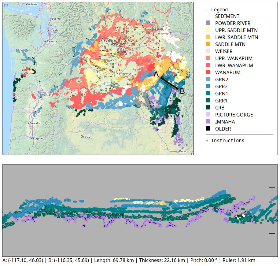
CRB Explorer is a purpose-built tool for visualizing digitized Columbia River Flood Basalt contacts in both 2D and 3D. Users can explore the distribution and deformation of Columbia River Basalt in Earth's youngest flood basalt province. CRB Explorer uses standards-compliant Javascript with no third-party libraries and the code base demonstrates patterns and methods for developing complex application-specific educational tools that can serve as a framework for future work.
Relevance and Context
Interactive digital tools are increasingly common in STEM education but the availability of such tools is frequently limited to on-campus workstations with specialized software preinstalled and centrally maintained. In many cases, these tools are available for students to download and install on their own computers. However, compatibility and performance limitations often limit accessibility, presenting unequal obstacles for students who rely on campus resources in order to access necessary materials. Furthermore, centrally maintained software imposes a logistical and financial burden on educational institutions, requiring that they maintain and support sufficient shared workstations. With the recent transition to remote learning, software accessibility has become an even more urgent issue, as access to on-campus facilities is limited by public health concerns.
Web browsers provide a standardized cross-platform environment that is optimized for rapid development of rich interactive user interfaces. Several examples of educational tools for life sciences have been released and distributed through custom web interfaces (Fisher, 2019; Scotti et al., 2020). Recent adoption of WebGL standards (The Khronos® Group Inc., 2020) in all modern browsers pushes these capabilities even further, enabling access to complex and potentially computationally-intensive software from any modern internet-connected device. By providing access to low-level system resources, WebGL opens the door to development of interactive 3D visualizations and parallel computations with relatively modest hardware requirements and nearly universal device compatibility.
CRB Explorer benefits from its "stateless" nature, executing completely within the user's browser with no server or database back-end, making deployment simple and free of charge via static hosting services like GitHub Pages. However, the same principles of accessibility apply to more complex software, and server-backed tools like JupyterHub (Jupyter Development Team, 2016) have potential for reaching students with limited access to computational resources. By lowering the barriers to entry, web applications such as CRB Explorer have the potential to expand access to specialized tools, allowing students to fully participate in their education.

Acknowledgments
The data set bundled with CRB Explorer was generated in collaboration with Gene Humphreys, Daniel O'Hara, Ana Mercedes Colón, and Nate Klema. It consists of digitized geologic contacts from publications of the United States Geological Survey and the Idaho Geological Survey. A complete list of geologic data sources is included within the online interface.
The bundled base map image was generated by OpenStreetMap.org, and is made available under the Open Data Commons Open Database License (ODbL) by the OpenStreetMap Foundation (OSMF).
This work was supported by National Science Foundation grant EAR-1727451.
References
Fisher, M. (2019). DraggleSimulator: An Open Source Web Application for Teaching Genetic Drift. Journal of Open Source Education, 2(21), 70. https://doi.org/10.21105/jose.00070
Jupyter Development Team. (2016). JupyterHub. https://jupyterhub.readthedocs.io/
Kauffman, J. D., Davidson, G. F., Lewis, R. S., & Burmester, R. F. (2005). Geologic map of the orofino west quadrangle, clearwater, lewis, and nez perce counties, idaho. Idaho Geological Survey. https://www.idahogeology.org/product/gm-40
Othberg, K. L., & Stanford, L. R. (1992). Geologic map of the boise valley and adjoining area, western snake river plain, idaho. Idaho Geological Survey. https://www.idahogeology.org/product/gm-18
Scotti, P., Kulkarni, A., Mazor, M., Klapwijk, E., Yarkoni, T., & Huth, A. (2020). EduCortex: Browser-based 3D brain visualization of fMRI meta-analysis maps. Journal of Open Source Education, 3(26), 75. https://doi.org/10.21105/jose.00075
Swanson, D. A., Anderson, J. L., Camp, V. E., Hooper, P. R., Taubeneck, W. H., & Wright, T. L. (1981). Reconnaissance geologic map of the Columbia River basalt group, northern Oregon and western Idaho. https://doi.org/10.3133/ofr81797
Swanson, D. A., Wright, T. L., Camp, V. E., Gardner, J. N., Helz, R. T., Price, S. M., Reidel, S. P., & Ross, M. E. (1980). Reconnaissance geologic map of the Columbia River Basalt Group, Pullman and Walla Walla quadrangles, southeast Washington and adjacent Idaho [USGS Numbered Series]. http://pubs.er.usgs.gov/publication/i1139
The Khronos® Group Inc. (2020). OpenGL ES for the web. https://www.khronos.org/webgl/