Eclogite-driven subsidence of the Columbia Basin (Washington State, USA) caused by deposition of Columbia River Basalt
I've been working recently on understanding the tectonic origin of the Columbia Basin, a large topographically low region that spans most of south-central Washington, and north-central Oregon. My paper on the results of that work comes out today in Geology, titled "Eclogite-driven subsidence of the Columbia Basin (Washington State, USA) caused by deposition of Columbia River Basalt" (Perry-Houts and Humphreys, 2018). This blog post parallels the paper's structure, and directly borrows some of its content, but omits some technical details in favor of narrative clarity. I don't make much of an effort to avoid jargon, but this should be accessible by anyone comfortable with basic geologic terminology. Some knowledge of western U.S. tectonics couldn't hurt, either.
The inter-montane lowlands of central Washington and Oregon subsided rapidly during the Miocene, coincident with the Columbia River Flood Basalt (CRB) eruptions to the East. CRB's flooded much of the pacific northwest with thick layers of basalt, but nowhere as thick as the central Columbia Basin, the region centered around Pasco, WA. The magnitude and rate of subsidence is unusual, as is the symmetry of the basin its self. For these reasons, we propose a novel mechanism for the development of the Columbia Basin.
We suggest that the CRB lavas themselves caused the Columbia Basin's subsidence, as increased lithostatic pressure, owing to CRB deposition, caused basaltic lower-crust to metamorphose eclogite facies. Eclogite, being substantially denser than the basalt it replaced, caused an isostatic adjustment of the crust, forming a topographic depression where subsequent CRB lavas would pond. This process repeated until CRB eruptions ceased in the late Miocene. We show, through numerical modeling, that this mechanism is capable of producing subsidence with the magnitude and rate observed in the geologic record. We also put new constraints on the mechanical properties of Miocene Columbia Basin lithosphere, finding it to be almost 80% thinner than previously thought.
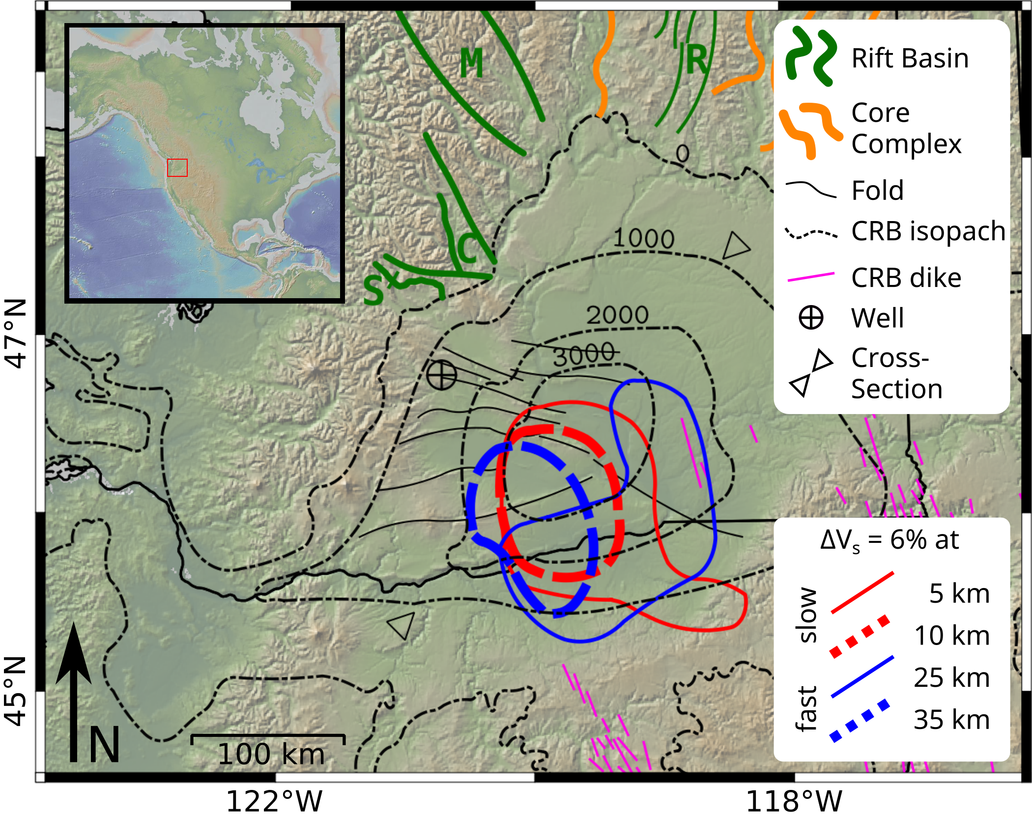
To step back a bit, the south-central portion of the Columbia basin is topographically low relative to its surroundings, and is underlain by about 4 kilometers of Columbia River Flood Basalt. The CRB's erupted mostly to the East, with the largest sequence sourced from a dike swarm centered around the Wallowa Mountains of northeastern Oregon. CRB deposits cover much of Oregon and Washington, but are nowhere more than a few hundred meters thick, except the central Columbia Basin. Even areas much closer to the source of the eruptions have thin CRB deposits compared with the Columbia Basin (Fig. 1).
Seismic tomography reveals a large high-velocity body centered below the basin, interpreted by Catchings and Mooney (1988) to be a basaltic underplate, suggesting the area experienced a failed rifting event during the Eocene. This could take us into what I think is a fascinating tectonic story, but I'm going to avoid taking this narrative too far off track. For now, the takeaway is that there appears to be a localized body of basaltic rocks in the lower crust, directly below the Columbia Basin.
The Columbia Basin is unique in both its anomalous CRB thickness, and in the structure of the basalt flows within. All resolvable CRB flows in the basin exhibit a symmetric "fanning" structure toward the basin center. That is, all basalt layers are thin near the edges, and thicker in the center of the basin (Fig. 2).
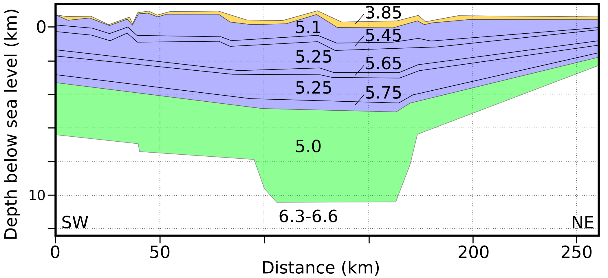
If the CRB had simply filled a preexisting basin with basalt, we would expect that the first few flows would flatten the topography, and subsequent flows would have uniform thickness above them. Rather, this fanning structure suggests that the basin was actively subsiding during the course of CRB deposition.
The CRB's erupted throughout the Miocene (~17—6 million years ago). However, about 72% of the flood basalt volume erupted in one phase, known as the Grand Ronde flows, which span less than half a million years, between about 16.0 – 15.6 million years ago. Reidel et. al. (2013) estimated that the Columbia Basin subsidence averaged 10 mm/year for 400,000 years!
If that rate of basin subsidence had extended beyond the time of CRB deposition, it would be obvious in the sedimentary record, and in the modern topography. Therefore, it appears that the basin subsided rapidly, and symmetrically, during, and only during, the deposition of Columbia River Flood Basalts.
There are few physical mechanisms that could produce such an event. Most traditional tectonic processes involve horizontal forces between plates, and tend to produce linear features like folds, faults, arcs, and so on; plate tectonics rarely creates radial symmetry on this scale. We therefore look to vertical forcing mechanisms for an answer.
In particular, we ask the question: is it possible that as lava erupted at the surface, the lower crust densified, forming a deep basin?
As with all scientific problems, we first try to show our story is not plausible, and hope it survives. We settled on two reasons this explanation might not hold up: either the chemical reaction dynamics of eclogite formation are too slow to be significant, or the tectonic plate is so strong that becoming denser will not produce the basin shape and size we see today. We test these two null hypotheses separately, using different types of mathematical models.
Chemical Reaction
Our first null hypothesis is the case where the rate at which a rock can metamorphose from basalt to eclogite facies is too low to explain the observed event time scale.
Experimental evidence suggests that hydrated basalt, as we would expect in the Cascades back-arc, can respond very quickly to changes in pressure and temperature (Ahrens and Schubert, 1975; Hacker, 2013). However, it's still possible that other reaction dynamics can inhibit the processes. Specifically, the phase boundary between basalt and eclogite has a positive Clapeyron slope. That is, you can increase the pressure of a basaltic rock until it becomes eclogite, but if you simultaneously increase the temperature, it will remain basalt. The reaction from basalt to eclogite is also exothermic, meaning that by metamorphosing one chunk of rock, you release latent heat into the neighboring rocks, inhibiting further eclogite formation. Until the extra heat has conducted away, the neighboring rocks will be unable to convert.
We model this system in the reference frame of a stationary observer, watching rocks "advect" from shallow to deep as they get buried, crossing the basalt-eclogite coexistence pressure as they go. To give away the answer ahead of time, our mathematical modeling indicates that geologic materials conduct heat much more quickly than latent heat can be released. Therefore, we conclude that the thermodynamics are consistent with our story.
Isostasy and Flexure
Our second null hypothesis is the case where strength of the tectonic plate produces deformation that is incompatible with observations. That is, the plate may be too strong, or too weak, to develop a basin with the Columbia Basin's geometry, given the hypothesized forces.
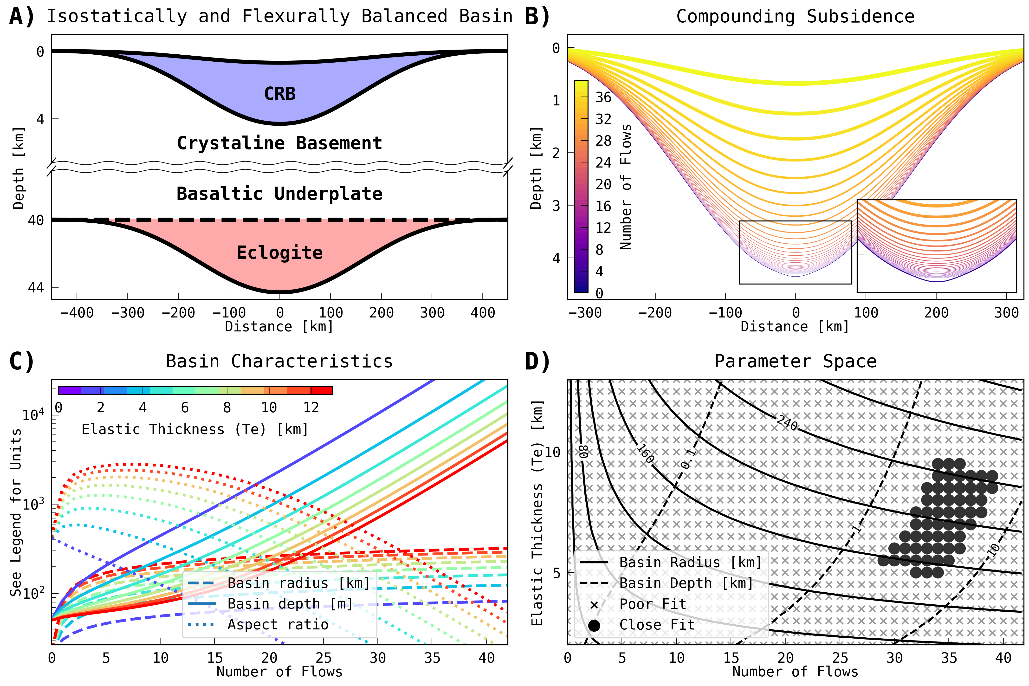
To test this, we again employ a mathematical model, now considering the lithosphere as an elastic sheet, isostatically supported from below. This exercise yields two interesting results—
First, we find that eclogite-driven subsidence acts as a positive feedback; once started, basin formation accelerates exponentially, ultimately only limited by the supply of lava at the surface.
Second, based on our models, eclogitization is capable of producing the observed basin geometry only if the tectonic plate has an effective elastic thickness between 5—10 km (Fig. 3)), where previous studies have predicted that the Columbia Basin has an effective thickness between 25—35 km (Lowry and Pérez-Gussinyé, 2011). We suggest that the discrepancy results from the peculiarly flat topography of the Columbia Basin, whose origin is incompatible with assumptions of the usual method for estimating plate thickness.
Most studies on lithospheric elastic thickness consider the ratio of Bouguer gravity to topographic roughness. The idea is that for a landscape to remain flat, it must be on very strong lithosphere. In the Columbia Basin, however, the landscape as been recently resurfaced by CRB deposition, making the usual methods less well suited here.
Based on the model results described above, and evidence that the Columbia Basin was geologically primed for such an event by the existence of localized lower-crustal basalt, we argue that the Columbia Basin likely did form owing to lower crustal eclogitization, ultimately driven by the weight of flood basalts on the surface. We can think of no other satisfactory explanation for the rapid, spatially and temporally localized subsidence of the Columbia Basin. If our interpretation is correct, we have also shown that the Miocene Columbia Basin crust was less than 10 km thick, an interpretation that may have significant consequences for paleo-tectonic reconstructions, and other tectonophysical predictions for the western U.S..
I encourage you to check out the paper for more information. It's only available behind a paywall until July 2019, but I'm of course happy to share a pdf by email.
Ahrens, T.J., and Schubert, G., 1975, Gabbro-eclogite reaction rate and its geophysical significance: Reviews of Geophysics, v. 13, p. 383-400, doi: 10.1029/RG013i002p00383.
Campbell, N., 1989, Structural and stratigraphic interpretation of rocks under the Yakima fold belt, Columbia Basin, based on recent surface mapping and well data, in Reidel, S.P. and Hooper, P.R. eds., Volcanism and Tectonism in the Columbia River Flood-basalt Province, Boulder, Colo, Geological Society of America, Geological Society of America Special Paper 239, p. 209-222.
Catchings, R.D., and Mooney, W.D., 1988, Crustal structure of the Columbia Plateau: Evidence for continental rifting: Journal of Geophysical Research: Solid Earth, v. 93, p. 459-474, doi: 10.1029/JB093iB01p00459.
Christiansen, R.L., and Yeats, R.S., 1992, Post-Laramide geology of the U.S. Cordilleran region, in Burchfiel, B.C., Lipman, P.W., and Zoback, M.L. eds., The Cordilleran Orogen: Conterminous U.S., Boulder, Colo, Geological Society of America, The Geology of North America, v. G-3, p. 261-406.
Fischer, K.M., 2002, Waning buoyancy in the crustal roots of old mountains: Nature, v. 417, p. 933-936, doi: 10.1038/nature00855.
Gac, S., Huismans, R.S., Simon, N.S.C., Podladchikov, Y.Y., and Faleide, J.I., 2013, Formation of intracratonic basins by lithospheric shortening and phase changes: a case study from the ultra-deep East Barents Sea basin: Terra Nova, v. 25, p. 459-464, doi: 10.1111/ter.12057.
Gao, H., Humphreys, E.D., Yao, H., and van der Hilst, R.D., 2011, Crust and lithosphere structure of the northwestern U.S. with ambient noise tomography: Terrane accretion and Cascade arc development: Earth and Planetary Science Letters, v. 304, p. 202-211, doi: 10.1016/j.epsl.2011.01.033.
Gaschnig, R.M., Vervoort, J.D., Lewis, R.S., and McClelland, W.C., 2010, Migrating magmatism in the northern US Cordillera: in situ U-Pb geochronology of the Idaho batholith: Contributions to Mineralogy and Petrology, v. 159, p. 863-883, doi: 10.1007/s00410-009-0459-5.
Hacker, B.R., 2013, Eclogite formation and the rheology, buoyancy, seismicity, and H2O content of oceanic crust: Subduction Top to Bottom, doi: 10.1029/GM096p0337.
Hamdani, Y., Mareschal, J.-C., and Arkani-Hamed, J., 1994, Phase change and thermal subsidence of the Williston basin: Geophysical Journal International, v. 116, p. 585-597, doi: 10.1111/j.1365-246X.1994.tb03282.x.
Ito, K., and Kennedy, G.C., 1971, An experimental study of the basalt-garnet granulite-eclogite transition, in Heacock, J.G. ed., The Structure and Physical Properties of the Earth's Crust, American Geophysical Union, p. 303-314, doi: 10.1029/GM014p0303.
Kruckenberg, S.C., Whitney, D.L., Teyssier, C., Fanning, C.M., and Dunlap, W.J., 2008, Paleocene-Eocene migmatite crystallization, extension, and exhumation in the hinterland of the northern Cordillera: Okanogan dome, Washington, USA: GSA Bulletin, v. 120, p. 912-929, doi: 10.1130/B26153.1.
Krystopowicz, N.J., and Currie, C.A., 2013, Crustal eclogitization and lithosphere delamination in orogens: Earth and Planetary Science Letters, v. 361, p. 195-207, doi: 10.1016/j.epsl.2012.09.056.
Lowry, A.R., and Pérez-Gussinyé, M., 2011, The role of crustal quartz in controlling Cordilleran deformation: Nature, v. 471, p. 353.
Naimark, B.M., and Ismail-Zadeh, A.T., 1995, Numerical models of a subsidence mechanism in intracratonic basins: application to North American basins: Geophysical Journal International, v. 123, p. 149-160, doi: 10.1111/j.1365-246X.1995.tb06667.x.
O'Connell, R.J., and Wasserburg, G.J., 1972, Dynamics of submergence and uplift of a sedimentary basin underlain by a phase-change boundary: Reviews of Geophysics, v. 10, p. 335-368, doi: 10.1029/RG010i001p00335.
Reidel, S.P., Camp, V.E., Tolan, T.L., and Martin, B.S., 2013, The Columbia River flood basalt province: Stratigraphy, areal extent, volume, and physical volcanology, in Geological Society of America Special Papers, Geological Society of America, v. 497, p. 1-43, doi: 10.1130/2013.2497(01).
Reidel, S.P., Tolan, T.L., Hooper, P.R., Beeson, M.H., Fecht, K.R., Bentley, R.D., and Anderson, J.L., 1989, The Grande Ronde Basalt, Columbia River Basalt Group; Stratigraphic descriptions and correlations in Washington, Oregon, and Idaho, in Reidel, S.P. and Hooper, P.R. eds., Volcanism and Tectonism in the Columbia River Flood-basalt Province, Boulder, Colo, Geological Society of America, Geological Society of America Special Paper 239, p. 21-54.
Ryan, W.B., Carbotte, S.M., Coplan, J.O., O'Hara, S., Melkonian, A., Arko, R., Weissel, R.A., Ferrini, V., Goodwillie, A., Nitsche, F., and others, 2009, Global multi-resolution topography synthesis: Geochemistry, Geophysics, Geosystems, v. 10.
Taylor, S.B., Johnson, S.Y., Fraser, G.T., and Roberts, J.W., 1988, Sedimentation and tectonics of the lower and middle Eocene Swauk Formation in eastern Swauk Basin, central Cascades, central Washington: Canadian Journal of Earth Sciences, v. 25, p. 1020-1036, doi: 10.1139/e88-100.
Turcotte, D., and Schubert, G., 2014, Geodynamics: Cambridge University Press.
Wang, H., and Currie, C.A., 2017, Crustal deformation induced by mantle dynamics: insights from models of gravitational lithosphere removal: Geophysical Journal International, v. 210, p. 1070-1091, doi: 10.1093/gji/ggx209.
Wilson, C.R., Spiegelman, M., and van Keken, P.E., 2017, TerraFERMA: The Transparent Finite Element Rapid Model Assembler for multiphysics problems in Earth sciences: Geochemistry, Geophysics, Geosystems, p. 769-810, doi: 10.1002/2016GC006702.
The thumbnail image is from Orr, E.L., and Orr, W.N., 2012, Oregon geology: Oregon State University Press, 304 p.